Monday, December 3, 2018

‘Tis The Season For King Tides…. What Could Possibly Happen?....

We are entering the season when we experience the highest tides of the year.  The term “King Tide” is nothing more than a slang term for extremely high tides.  In our area, all waterfront properties need to pay attention to these tides.  There is a LOT more to it than just what you see on the Tide Chart.  In this blog I want to share some science, some anecdotal stories and a worst case scenario backed with historical data.

The Science:
Tide levels are affected by multiple factors.  All tide charts are calculated using a “static” barometric pressure of 29.91” or 1013mb.  This is the average barometric pressure.  As the barometric pressure rises, this additional pressure actually pushes the water down.  The opposite is true as well.  As the pressure drops, the water levels rise.  In a simple, static situation this is fairly simple to calculate.  I have this tide impact value in real time on my site.  For every millibar change in pressure, the sea level will change by 1 centimeter.  In the case below, the barometric pressure is 1019mb.  That is 6mb above the average 1013.  Because the pressure is higher than average it is pushing the water down.  This results in the level being 6 centimeters or approximately 2 inches below the forecast level.


This highlighted value above is hyperlinked to the chart below that shows tide impact at multiple barometric pressures.


So this covers the "easy" calculations for tide level.  Barometric pressure is just one of the elements that can affect predicted tides. 

The other factors are:

Storm Surge – This is caused by the wind pushing the water onto the shoreline.  It can be a VERY significant effect during storms.  This is what we hear about all the time with hurricanes.  The same physics apply to our wind storms, just at lesser level.

Heavy Rainfall and run off can increase sea level close to shore.  Rainfall alone can cause shoreline flooding.

Shoreline Contours and restricted bays can also affect sea levels.

Enough science….  Now for a story….

A Little History and a Story
In the early 80’s we had a storm I will never forget.  I was Fire Chief at the time and I saw an incredible amount of destruction.  This was pre-internet and forecasts were still done on TV with a chalkboard.  I didn’t even have a weather station.  I woke up in the middle of the night and the wind was howling.  It also sounded a little different too.  The power was out as well.  At 5:00am I got a frantic phone call from one of our volunteer fire fighters.  He said that his house, garage and car were under water.  Everybody in his area was experiencing flooding.  I jumped in my car and took off right away toward his place.  When I got close to the Nature Conservancy on Twin Spits road, it was flooded….  With salt water.....  Rawson Swamp was overflowing onto the road.  I looked at it carefully and took a chance to traverse this area that had floor board level water.  I was informed that shortly after I went through it was impassable.  When I got to the firefighters home it was exactly as he described.  Houses, garages and cars flooded….  I really couldn’t believe what I was seeing.  There was nothing we could do but wait for the wind and tide to subside.  I ended up spending that time with an elderly woman that lived alone.  The waves were crashing directly into her home.  The whole house shook violently with every wave that struck it.  When the tides subsided we saw that her 12” concrete bulkhead had been totally destroyed.

This is just one of many stories of destruction from that day.  Many homes were flooded and roads were impassable.  Cars were destroyed.  There were stories of folks finding their chest freezer at the other end of their garage after the flood.  I could go on and on about this horrific experience.  Yes….  Peaceful Hansville can have catastrophic storms.

So…  What happened with this storm?  We were watching our analog barometer drop like a rock the night before, so I knew something was coming.  As I said, it sounded different….  That is because this incredible wind was out of the East or ESE.  This is a rare direction for us.  I would estimate the wind gusts at 50+ mph.  This all happened at the exact same time of a king tide.  Low barometer, high winds and high tides are a formula for disaster.  Are we prepared?

Worst Case Scenario:
I would like to share some video and then create a case study for a worst case scenario.  First, let’s look at the video.  This was taken on January 18, 2017.  We had a very high tide and low barometer and I drove around Hansville to see what areas were impacted.


Now I have some data to lay over this video.  It was taken after high tide and the water had already receded about 12".  The forecast high tide was 11.45 feet at 8:35am that day.  At high tide, the wind gusts were 16 mph.  The barometer was 29.26” or 991mb.  This would impact the tide by +9”.  The net result would be a high tide of 12.2 feet.  Since the video is after the high, it is probably around 11.2 or so.  Of the 3 elements that can really cause flooding, it was a “so-so” event.  The forecast tide was high, but not real high.  The barometer was low, but not real low.  The wind was essentially not a factor.  I’ll share one more observation from that day.  The Driftwood Key launch ramp was completely under water.  In fact, half of the parking lot was submerged too.

So, let’s put together the perfect trifecta for disaster.  Think of the video you just watched and we’ll adjust a few factors.  First, let’s start with changing the forecast high tide to 13.5 feet.  Yes, it’s possible....  The lowest barometric pressure I have recorded on my site is 28.65” or 970mb.  Let's use that number....  The high winds my site recorded over that period were 46mph.  I had a shorter anemometer mast back then, so realistically the winds would have been 50+ mph.  Fortunately the high tides that day were "only" about 9.75 feet.

So, let’s run the numbers. Barometric pressure of 28.65” results in an additional 17” to the high tide.  If the predicted high is 13.5 feet, the actual theoretical high tide would be 14.9 feet.  For good measure, let’s add some 50mph wind.  This could easily add another foot or two.

In the video, sea level was about 11.2 feet.  This worst case scenario would result in a 14.9 ft. tide….   plus another 2 foot storm surge.  Watch the video again and visualize sea level about 5 feet or more above what you see….  With 50mph winds.

Are We Prepared?
This is an extreme depiction of what "could" happen.  More than likely we will never see this, but something in between is definitely not out of the question.  Are we prepared?  It’s not just waterfront properties.  Roads would be blocked in this scenario due to flooding.  Do you know where the flooding will be and do you have an alternate route?  Floods happen fast.  

I put together a chart showing all remaining high tides above 11 feet this year.


Saturday, November 17, 2018

A Meteor and The Mountain....

The clear skies are giving us some great views....

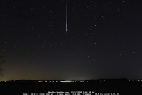
First, my good night cam picked up a nice meteor this morning.  Last night was prime for the Leonid meteor shower, although this fireball is probably random.  The Leonids are typically smaller.  Click on the image for a better view.

Edit: I just consulted with Robert Lunsford of the American Meteor Society.  He is certain that this is a Taurid fireball.  The Taurid meteor shower is active right now too.


Now that the sun is up, Mt. Baker is out in all her glory....


Thursday, November 15, 2018

A Windy November....


Anybody else notice how windy this November has been here. I just went back and looked at the number of days we have had wind gusts 40 mph and above. So far this year in 14 days we have had 4.... For numbers geeks that is 29% of the days so far.... Here is a summary from my system going back to 2006... 2014 was windy, but we are still on track to beat that number this year...


Wednesday, November 14, 2018

Strong Winds and California Smoke

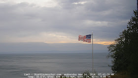
The winds REALLY picked up this morning.  As I type we are having consistent gusts over 40 mph.  Highest so far is 43.  At the same time, our air quality is deteriorating.  This strong southerly flow is actually carrying smoke from California into Oregon and Washington.  Right now the air quality in the Cascade foothills is "Unhealthy For Sensitive Groups".  What a paradox....  Last summer we wanted the wind to get rid of the smoke and now the wind is bringing the smoke to us.  This really speaks to how bad it is in California.  Thoughts and prayers to them....


Monday, November 5, 2018

A Brief Northern Lights Display....

Last night the clouds parted for a brief moment to reveal the Northern Lights on the horizon....  Click on the image for better viewing.....


Monday, October 29, 2018

Stars Coming Out At Moon Rise and an Atmospheric River Coming Our Way.....

Last night, just as the moon rose, the clouds parted to reveal the stars....  It made for a beautiful sky...


It is interesting to watch in time lapse....


And then for the bad news from that fun squasher Cliff Mass....  It looks like we have a major atmospheric river coming this weekend.  Yuck....


Here is the link to Cliff's blog:


Friday, October 19, 2018

Fog Isn't Always Ugly....

Whenever we are socked in with fog, I watch it as closely as I can when I am home and have access to my drone.  Above the fog photography at the right time can be beautiful....  It is illegal to fly a drone in the fog, so timing is everything.  It has to be clear overhead and foggy around us.  I got lucky this afternoon and put the drone up the minute it cleared overhead....  This fog was beautiful as it cleared over Hood Canal....


Here is a video of the fog as it was clearing.


Thursday, October 18, 2018

A Pink Sky Sunrise....

Another incredible sunrise this morning.  The whole sky was pink.....


Here is a spin showing Admiralty Inlet, Hood Canal, Mt. Baker and Puget Sound...


Tuesday, October 2, 2018

A Pretty Amazing Sunrise....

This morning produced an incredible sunrise that I wasn't expecting.  Watch to the end to see an interesting double rainbow.....


And from ground level, this is what it looked like from 3 cams....


Saturday, September 29, 2018

Moon Rise Into Sunrise - 9/29/18

The moon rise last night was awesome and the sunrise wasn't too bad either.


Saturday, September 22, 2018

MoonBow - September 21, 2018

Did you see the Moonbow last night around 10:45?


Tuesday, September 4, 2018

Interesting Iridium Flare Followed By An All Night Time Lapse

Thought I would share this video.  An interesting Iridium Flare caused by a satellites reflection from the sun.  Then it is followed by an all night time lapse.


Monday, September 3, 2018

Nice Meteor This Morning

The skies finally parted last night and we were able to see the stars and a nice meteor.....


Wednesday, August 15, 2018

Seattle's Worst 24 Hour Air Quality On Record...

Just when I thought it couldn't get worse, I woke up this morning with the familiar burning eyes and sore throat.  I could barely see my neighbor's house (slight exaggeration...)  Whidbey Island is missing....  So I put the drone up to see how bad it was.  This is definitely worse than yesterday.


There are rumors of relief starting tonight...  I can hardly wait!

Meanwhile, Cliff's Blog about this record breaking event is pretty interesting...

Cliff Blog About Record Setting Smoke - Click Here

Tuesday, August 14, 2018

The Smoke Continues....

The smoke this morning is awful....  The forecasts show some temporary relief for later today, but until these wildfires are contained, we will be in an on again off again smoke situation depending on the winds.  I took this drone video this morning. 


Cliff Mass used this video in his blog this morning.  He shares some good information about this smoke event....  Cliff's Smoke Blog - August 14th

Sunday, August 12, 2018

More Smoke Coming... From All Directions?...

Cliff Mass just posted an interesting blog that coincides with what I am seeing.  The clouds I saw this morning seemed to be replaced with smoke.  We have a strong North wind blowing now, so the Maple fire and California smoke seemed illogical.  But it definitely looked like smoke....  Well...  We are now sharing smoke with BC again.  If I am reading Cliff's blog correctly, we have BC's smoke now and it will soon combine with California's smoke and eventually Eastern Washington smoke....  For a guy with asthma, this is NOT good news.....  It's also bad news for those looking forward to the Perseid meteor shower....

Click Here For Cliff's Smoke Blog... 

Saturday, August 11, 2018

Time Lapse Storm Recap From Today.... August 11, 2018

The weather today turned out as promised.  Actually, we avoided the BIG hit.  I put it into a time lapse that shows Cam1, Cam2, Cam3 and then a panorama of all three.  It's a bit long at just under 2 minutes, but worth watching to the end....


Possible Lightning Today... And a couple of tools on this site to monitor this event..

We are looking at potential lightning here this afternoon.  This doesn't happen a lot around here and I think we all need to be reminded how to be safe during these events.  About 30 years ago when I was young and dumb, I was fishing in a 14ft. aluminum boat under jet black skies.  A bolt of lightning hit the water less than 100 feet from me.  Yes, that was a very religious experience.  I couldn't hear or see anything for a while after it happened, because it was so loud and bright.  Plus every hair on my body was standing at attention.....  That event "inspired" me to stay off the water when lightning is in the area.  A boat is a perfect target.

I have some tools on my site that I thought I would share in this blog.  The first is the CAPE Forecast tool.  This is down in the "National Weather Service" section.  CAPE is an acronym that stands for "Convective Available Potential Energy".  The weather service can measure the amount of energy an air particle would have if it was lifted in the atmosphere.  If it creates enough energy, it results in lightning.  

When you click on the "CAPE Forecast" link, you will get an interactive screen that looks like this.  You can see it is for 8:00am today.  The pink off the coast is potential lightning.  These forecasts are in 3 hour increments.  I will share the forecasts for today below:


11:00am - You can see the potential starting to move into Puget Sound


2:00PM - You can see it has us covered and a new color is introduced....  This is a higher potential.


5:00PM - It pretty much has saturated our area.


8:00PM - Still pretty solid, but starting to lighten up.


11:00PM - It finally starts to clear up....


So, we could have some interesting weather today.  There is one more tool to share from the site.  It is an interactive lightning map that shows where lightning has struck.  The link is right below the CAPE Forecast link.  Here is a direct link to that site:  Lightning Map

Be Safe Today!


Monday, July 30, 2018

Smoke On The Water... Coming our way...

Edit 7/31/18  7:00AM:
The NWS just released a new forecast and it appears that the smoke will veer to the East...

NWS Smoke Forecast

Today would have been gorgeous blue skies and water... Except... We are slowly being inundated with gray smoke. 

We had the opportunity to take some friends from California out for an extended boat ride. We launched in Kingston and then ran all the way around Bainbridge Island and back to Poulsbo for a late lunch. While we were on the water I watched as the smoke got thicker and thicker on the horizon. We had a great vantage point. 

Unfortunately…. This is only the beginning and things will likely get much worse…. California smoke is coming our way and odds are there will be some local fires as well. 

I took an aerial spin this evening that shows the encroaching smoke. Tomorrow night will probably be worse.... 


There is some very good information from Cliff Mass’s blog from this morning.

http://cliffmass.blogspot.com/2018/07/smoke-reaches-western-washington.html


Thursday, July 5, 2018

Noctilucent Clouds - A Great Show Yesterday and Some Interesting Facts About Them


On the morning of July 4th we had a HUGE Noctilucent Cloud show.  There was a brief showing the evening before and then shortly after 2:30am on the 4th the sky exploded with a beautiful display.


Noctilucent Clouds ("Night Shining Clouds") should not be confused with our “earthly” clouds.  These have nothing to do with weather.  They are actually frozen space dust particles floating around 47 to 53 miles above the earth’s surface.  They are visible on the Northern horizon.

The conditions have to be just right for us to see them.  Technically, we are too far south to be in the "sweet spot" for viewing.  They are normally only seen between 50 and 70 degrees latitude.  We are at 48 degrees.

They are only visible for a few weeks either side of the summer solstice.  I have captured them from late May and into the middle of July.

For those who like their sleep...  This may not be a popular event since they are only visible during "Astronomical Twilight".  This varies throughout the year, but right now it is about 3 hours before sunrise....  The chart below shows the current "Twilight" times for our area.  


All of these conditions have to come into alignment before these ice particles can be illuminated.  The sun has to be at just the right angle where it is lower than the horizon, still dark at our level and at the same time illuminating these particles.  The graphic below demonstrates this.


A lot of things have to be just right for us to enjoy events like this.  Plus, there is no way to forecast if they will be visible.  Conditions my be just perfect and they won't show up.  They are very fickle. 

A VERY interesting fact about Noctilucent Clouds is that there are no documented reports prior to 1885....  That can open a ton of questions about..... "Human Caused" vs. "Alien Caused" vs. "Climate Change"....  Have fun with that one.... :)

Still images are beautiful, but I really like how Noctilucents move in a time lapse video.  Here is a compilation from 3 of my cameras.


For the record...  I like my sleep....  That is why I have installed all these automated cameras.... :)  I am a lazy photographer....

Tuesday, July 3, 2018

Are Personal Fireworks Worth The Cost?

Cliff Mass does an excellent job of covering the price we all pay for fireworks on the Fourth of July.  There is a lot of good information and he shares the science behind the true impact of this holiday.

He mentions:
  1. Wildfires
  2. Air quality
  3. Injuries
  4. Pets
I would like to add a couple more....  

This should be a time to celebrate our country.  It should also be a time to respect and thank the Veterans who have given us this freedom.  PTSD is very real and many of our veterans suffer severely from this.  This holiday is nothing short of torture for those suffering from PTSD.  Today I spoke with a woman whose neighbor is tortured every year from these fireworks.  He served our country honorably.  He has to be sedated and his wife at his side covering him with a blanket and soothing words to get through the 4th.  I am sure he does not feel appreciated or celebrated during this time.  Just something to think about....

I love our beautiful environment and the wildlife we enjoy year around.  This is why I do what I do with Skunk Bay Weather.  This holiday brings torture to all the beautiful wildlife around us.  If we love the wildlife, why do we allow this to happen.  Just something to think about....

I know that folks who live up here truly appreciate the tranquility and beauty of our area.  Most of those I talk to in the area, do not appreciate or enjoy this holiday because of what it has become.  Fireworks bought on the reservation are not legal off the reservation.  Just something to think about.....    

Please take a moment to read Cliff's excellent blog.  He shares some very interesting scientific facts about the end result of this holiday...

Cliff's Blog     

Wednesday, June 13, 2018

Skunk Bay Missile Crisis Over


This has been a very active few days…  My website, Twitter, Facebook and even this blog have had record breaking activity.  It has been impossible to keep up with it.  I have gotten hits and inquiries from all over the world.  I knew when I went public with these images, it was going to be very active.  Well…  I think that was an understatement.


Here is a little history and my reasoning for declaring the Skunk Bay Missile Crisis over. 

When I first saw that image, there was no doubt about it in my mind…  That was one big missile launch.  That’s why I waited for 24 hours before going public.  Cliff Mass and I shared several emails before he posted his blog.  As the day progressed, there were no reports of anybody else seeing it or hearing it.  That is a big, important fact.  A missile of that size would make a lot of noise.  But, the image was so compelling, I really could not completely let go of the theory.  I study these images every day…  Thousands and thousands of these images and have never seen anything like this.  But with no reports of anybody hearing it, I parked it in my mind as a mystery, rather than a fact.  Theories about it being a plane I discounted because they were not in the field of view of my cameras and I see thousands of planes fly over and they don’t look like this image at all.  Tyler Rogoway, an aviation specialist did a lot of research and found it matched an Airlift NW helicopter path perfectly.  But, I still could not buy into it.  Helicopters fly over all the time and they have never looked like that.  The conspiracy theories were rampant, but I could not get on board with them either….  I kept this thing parked as a mystery.  This morning I contacted Air Lift NW to find out if the Nav lights on the helicopter were different in any way.  I got a fairly quick response back from them after they talked with the pilot.  Here is the text:

"They were transiting from Bremerton to Bellingham on a standard instrument flight plan, flying in the clouds with night vision goggles. The search light was retracted flush under the nose, but did not switch off and was facing straight down."

So, the path of the helicopter matches perfectly and now that I know the searchlight was in a locked down position and still on, it makes sense now.

I know my cameras very well.  This was a unique situation that would have resulted in exactly this type of image.  I never thought it would be solved like this….  What an adventure.

I know that many folks will vehemently disagree with this assessment, much as I did in the beginning.  I hope they do continue to keep searching for another explanation, but in this case, I am 99% convinced this is the real solution.  I will always leave that 1% open out there because I love a good mystery…..  :)

Cliff Mass does a great job of giving the details in his blog this afternoon:

http://cliffmass.blogspot.com/2018/06/mystery-missile-launch-explained.html


Monday, June 11, 2018

Missile Launch On Whidbey Island?

I have been sitting on this since yesterday morning…. My night camera picked up what clearly looks like a very large missile launch from Whidbey Island. I really wanted more information before I shared this with the public. KOMO, KING and KIRO all contacted Whidbey NAS and the Department of Defense. They all said it didn’t come from them…. They said they don’t have the facility to launch large missiles. I ran this image by Robert Lunsford of the American Meteor Society and he said it was definitely not a meteor. It looked like a missile launch to him as well. I shared this with Cliff Mass yesterday and he did a blog on it this morning. It will be interesting if anybody from Whidbey heard or saw this event. 

Click on these images to see them full size.  Here is the full size image:


Here is a blown up crop of the "missile" at the top of the plume....


Wednesday, June 6, 2018

Nice Fireball Overnight

We had a very large fireball about 1:00am this morning. 

Here is the image and an overnight time lapse:


Here is a single image:

Friday, May 25, 2018

A Little Catch Up ..... Some Time Lapses From The Last Few Days....

There have been some incredible time lapses and images in the past few days and I am just now getting around to posting them.

Sunrise 5/25/18


An Aerial Sunset Video - 5/24/18


Sunset From Cam 1 - 5/24/18


A Starry Night Under A Bright Moon - 5/24/2018


On May 22 there was blue sky above me and fog all around.  I put the drone up to see what I could see...  It socked in really fast and I brought the drone down as fast as possible.  It made for an interesting video....


It's been a pretty active few days.  On another note, I am on Instagram now as well.


Thursday, May 17, 2018

Sunset - May 16, 2018

A very nice sunset last night....  Had to go up in the air to see it from here...


Tuesday, May 15, 2018

The Air Conditioner Has Arrived.....

Mother Natures air conditioner arrived in style this morning.....


Thursday, May 10, 2018

2018 Weather Workshop Video


I was asked to share my presentation video from the PNW Weather Workshop to the public this year.  I have also shared this video with the Hansville Community Center and the North Kitsap Puget Sound Anglers Association.  It is a 12 minute video that shows some of the beauty that has happened in the last year.  I cannot put it on Youtube, Vimeo, Facebook or Twitter because of copyright protection of the music.  I am probably at risk of a lawsuit for using and sharing this music... but… In my opinion, I am not only promoting the beauty of Mother Nature (more importantly), but I am also promoting the incredible music from the artists listed below as well as others.  For the record, I have NOT made a dime from this video.

George Winston
Phillip Wesley
Eric Clapton
John Barry

The closing song...  "Tears In Heaven" is a song that I ask you all reflect on.  The words and music are beautiful.  Eric Clapton wrote it to his 4 year old son who tragically fell to his death from a window in their 95th story apartment.  Chances are... We have all lost some important people in our lives recently.  I know I have....  My dream... and prayer.... is that heaven is as beautiful as the morning Mother Nature gave to my camera that day.

This video file is very large and I don’t want to reduce the quality too much. 

The best video (largest file) will be in 1080 here:  http://www.skunkbayweather.com/WeatherWorkshop2018.mp4

A slightly smaller file that "may" play well on slower connections is here: 

I really don’t want to reduce the quality below 720.  I am sorry to those who cannot play this video due to internet connection speed.

This is an image from the end of the video...


Sunday, May 6, 2018

Incredible Sunset....

Last night we had a remarkable sunset.  The images from all over were incredible.  This is an image from Cam1....


Here is a time lapse of the sunset into this morning's sunrise...  and a rainbow from yesterday.