We had a very nice Moonbow (Lunar Rainbow) this morning. It is caused by the light of the moon rather than the sun.
Monday, November 30, 2020
Monday, November 16, 2020
More Wind Coming Tuesday....
The NWS just issued a Gale Watch for Hood Canal/Puget Sound for tomorrow and a High Wind Warning for Admiralty Inlet. There is a very interesting storm brewing off Vancouver Island.... A "Meteorological Bomb". Cliff Mass tells the story in his blog:
https://cliffmass.blogspot.com/2020/11/a-meteorological-bomb-will-hit-northern.html

Tuesday, November 10, 2020
Possible Big Windstorm Friday/Saturday?
Update: 11/12/2020
It appears that this storm is coming ashore off the Oregon coast and will not affect us as much as thought earlier. Cliff Mass covers this nicely here:
https://cliffmass.blogspot.com/2020/11/storm-approaches-with-high-winds-south.html
_______________________________________________________________
This is just a FWIW post.... But worth paying attention to. Many of the forecast models are hinting at a major wind storm for Friday night/Saturday morning. There is a lot of uncertainty this far out, but I think its important to be aware and prepare as best we can. Cliff Mass covers it very well in his blog this morning....
The image below is what forecasters use and paints a pretty grim picture. The lines on this image are called isobars and represent barometric pressure and visually shows pressure difference (pressure gradients). A simple rule is if there are 11-13 isobars between Portland and Bellingham you are looking at a significant wind storm. For my aging eyes I lose count there are so many isobars but it gets close to the Inauguration Day storm level..... The Inauguration Day storm was around 21.5.....
This will be something to watch over the next few days.....

Sunday, November 8, 2020
Just How Windy Has This Month Been?
I was asked if this month has been abnormally windy. I created a measure that I have tracked since 2013. I call it "Wind Minutes". It is the number of minutes where the wind gusts are greater than or equal to 30mph. I put together a table this morning measuring November 1-8 since 2013.
YES.... This has been a VERY windy start to November..... And we are still counting for today....

Monday, September 28, 2020
A Slight Aurora Borealis Show
The bright moon will be an issue viewing Aurora during this storm. There was just a bit of a show last night with a bonus meteor.

Friday, September 18, 2020
Making Sense Out Of Those "Crazy Good" Air Quality Index Numbers
Scott Sistek has put together a nice blog about why some of the sensors are showing "Good" quality air when the smoke is still thick..... It turns out those sensors don't measure smoke...

Saturday, August 1, 2020
A Nice Bright Fireball
Update: The American Meteor Society has updated the reports about this meteor. Below is a map of where the reports came from and the calculated trajectory. It turns out this meteor came down up by Prince George BC. It had to REALLY be bright up there....

This morning we had a very bright fireball. Notice the reflection on the water in the image below. This meteor is a late Southern Delta Aquarid shower.

Cam2 also picked it up.

Monday, July 20, 2020
Comet Neowise Time Lapse Archive
I have accumulated quite a few comet images and time lapses over the last few days. I thought I would put together an archive of how it is progressing over time. The best quality videos are direct links to the video itself on my site. It does require a fast internet connection. I will continue to update this as we watch Neowise slowly disappear.
Click on the dates below this image.


Saturday, July 11, 2020
Comet Neowise Time Lapse
Update - July 13,2020

July 12, 2020
The comet was visible all night. Here is an image from sunset:

Here is a time lapse from last night (7/13/2020):
Comet Neowise was clearly visible this morning. The time lapse is interesting to watch how it traverses the sky.
Thursday, June 18, 2020
Best Yet Noctilucent Show...
I have seen a lot of Noctilucent clouds over the years, but this morning's was by far and away the most ominous. At 3:00am our bedroom was completely lit up by this show.... Best watched full screen.
Tuesday, June 2, 2020
First Noctilucent Clouds of the season....
This morning we had the first Noctilucent Clouds of the season put on a show....
Some of the interesting facts about Noctilucent Clouds are covered in Scott Sistek's blog this morning. The Noctilucent "season" is active about 3 weeks either side of the Summer Solstice.

Some of the interesting facts about Noctilucent Clouds are covered in Scott Sistek's blog this morning. The Noctilucent "season" is active about 3 weeks either side of the Summer Solstice.

Thursday, May 7, 2020
An Exploding Meteor and Sonic Boom Over Puget Sound Last Night
There were numerous report of a huge boom that shook houses in the area last night. Most of the reports were from Bremerton to Seattle. Scott Sistek does a nice job covering this event in his blog this morning....
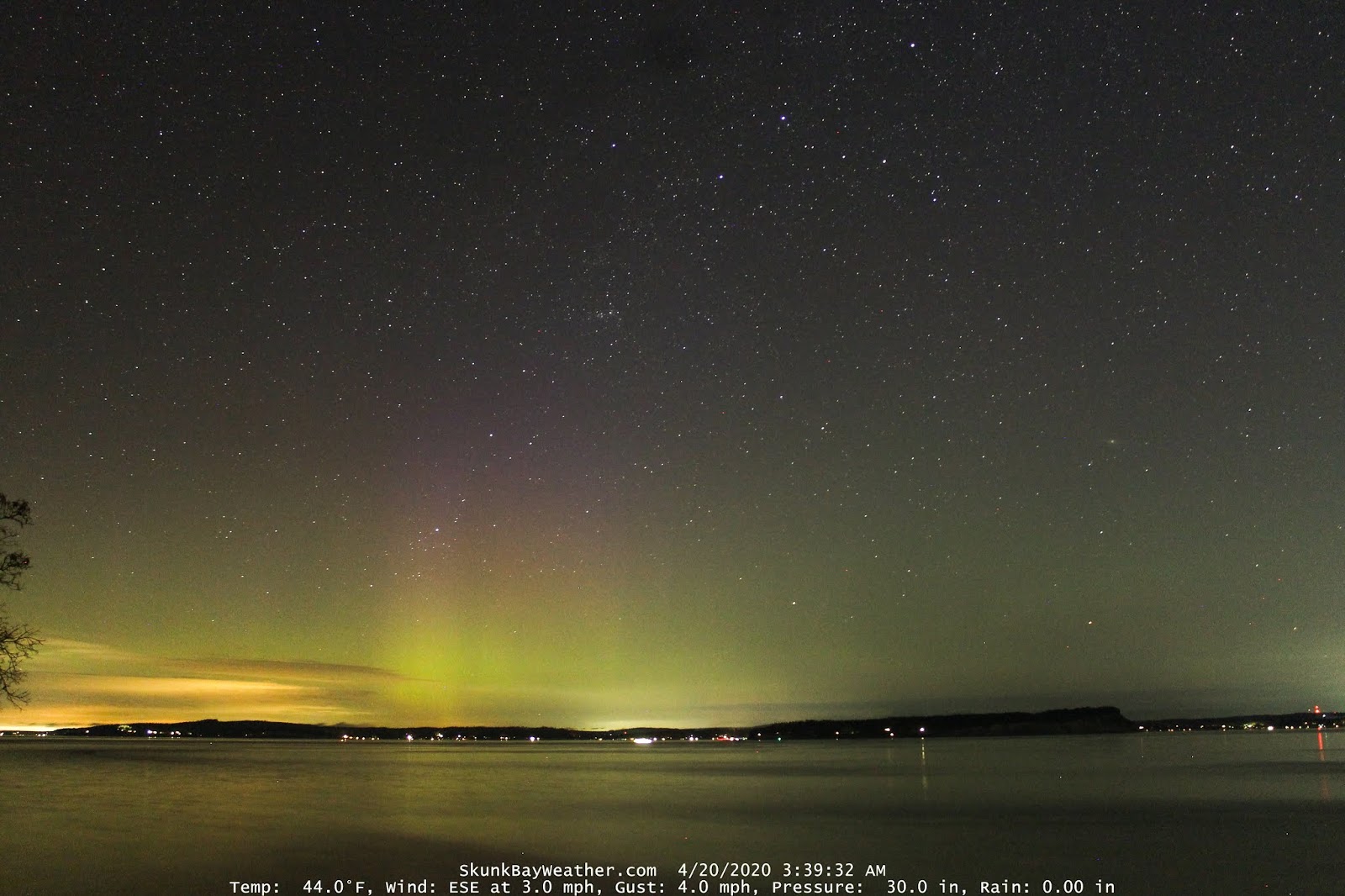
Monday, April 20, 2020
Lyrid Meteor this Morning and Northern Lights Yesterday
The skies have been active the last few nights... Northern Lights on Monday morning and a nice Lyrid meteor on Tuesday. This is an addition to yesterday's blog.
This meteor capture was within minutes of the clouds covering the sky... Yes it was a lucky shot for multiple reasons.... The Lyrid meteor shower should be peaking tonight and unfortunately it will be blocked by clouds. Here is an enhanced image of this morning's meteor. It was confirmed to by a Lyrid by Robert Lunsford of the American Meteor Society....
I was going to do a quick blog on this Northern Lights show and then Cliff Mass did a WAY better job than I could do.... I'll share an image and time lapse, but the best information is here on Cliff's Blog- Click Here
Tuesday, March 17, 2020
St. Patrick's Day Sunrise....
A moment of peace and tranquility during very stressful times thanks to Mother Nature....
Monday, January 13, 2020
A 3 Cam Panorama Time Lapse Of 1/12/20 Convergence Zone
Yesterday was an eventful weather day. I put together a 3 camera panorama time lapse of the convergence zone that rolled through. The panorama view makes it easy to see all the moving parts....
Friday, January 10, 2020
What Are You Doing In Preparation For This Coming Cold Weather?
With this extreme cold weather coming, I have been hoping I haven't missed anything that needs to be winterized. In the past on Facebook I have started a list of items that need to be winterized in preparation for cold weather and asked folks to contribute their thoughts. It was a good conversation. We can all learn from each other. So I'll start this with a simple list of 10 items.... (I have already done a lot more, but they are specific to my home). Leave your comments and after my review they will be posted.

- Drain all garden hoses
- Cover outdoor faucets with insulated covers
- Cover crawl space vents
- Service and run generator
- Fill all extra gas cans
- Fuel up cars
- Make sure cars are parked where they can get out if the snow piles up
- Lift windshield wipers vertical so they don’t freeze to the windshield
- Flush boat motors with environmentally safe antifreeze
- Lower boat outdrives so they drain

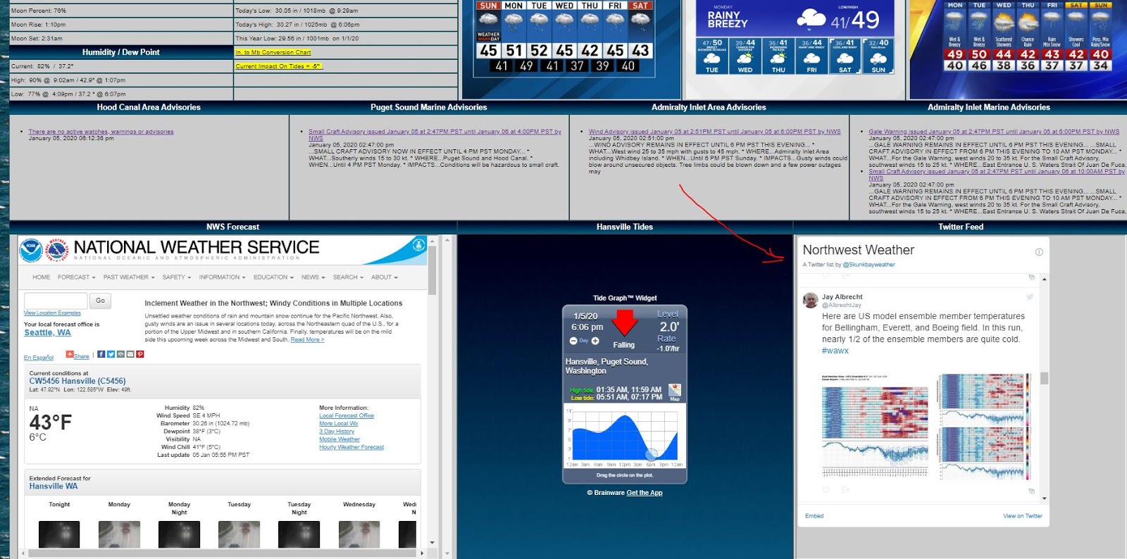
Sunday, January 5, 2020
Rumors? .... Or Early Forecasts For Preparedness....
I have been watching comments from respected meteorologists
around the area about next weekend for a while now. The models and ensembles have been very
interesting. Some models have been
promising a NASTY arctic flow and gobs of snow.
Most of the other models not so much or nothing at all.
So, at this point we can classify the “snowmaggedon”
forecast for next weekend as “rumor”. Anything
beyond 3 days out is a tough call and the accuracy can be questioned. At 3 days they do become very accurate.
Personally I like these “rumors”…. I look at them as a reminder to prepare. I really think the forecasters are doing us a
service. I leave a lot of the
winterization projects to the last minute, because many years they are not necessary. So, thanks to the “rumors”, I am going to
prepare “progressively” to do some of the winterization projects that I wouldn’t
have prepared for otherwise. I’ll be reviewing
all that needs to be done and restocking necessary supplies now instead of
later when it could be too late…. (been
there and done that)…. If this doesn’t
happen, it is not a problem. I’ll have extra
supplies for next year.
Key point here…. “rumors” can be good if it inspires us to be
prepared.
Meanwhile, I think we all should be watching the upcoming
forecasts closely. I have a Twitter List
on my site that includes many talented meteorologist comments from our
area. I use it daily to get a lot of my
information.
Wednesday, January 1, 2020
Video Review of New Years Eve Storm 2019
Happy New Year to everyone.
2019 went out with some fanfare.... It was a very active weather day. Our winds topped out at 40 mph and we had some brief heavy showers. There were several rainbows and a long lasting, unusual cloud over Whidbey Island that almost looked like a roll cloud, but it's not. There was so much to look at I decided to just put together a video summary of the day from the 3 cams.

2019 went out with some fanfare.... It was a very active weather day. Our winds topped out at 40 mph and we had some brief heavy showers. There were several rainbows and a long lasting, unusual cloud over Whidbey Island that almost looked like a roll cloud, but it's not. There was so much to look at I decided to just put together a video summary of the day from the 3 cams.
Below is an image of Double Bluff on Whidbey Island that shows why the National Weather Service posted Gale Warnings....

Subscribe to:
Posts (Atom)