We have all heard enough about the record breaking rainfall
this year and I don’t want to depress us even more… But there are some interesting facts about
our local rainfall that I thought I’d share….
Last year we actually had MORE rain than we have had so far
this year…. By April 9th last
year we had 15.38” and this year we “ONLY” have 13.73”….. Last year started out REALLY wet and we had a
great summer…. So there is hope.
Now for the depressing facts…. We just survived the wettest rain season
(October-March) that my station has recorded.
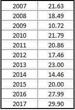
Here are the numbers:
OK... Enough of this depressing stuff.... Let's enjoy the sunshine today!

Edit... 9:45
The NWS discussion that just came out is GREAT! Just proof that when the times get tough... all you should do is laugh....
Area Forecast Discussion
National Weather Service Seattle WA
933 AM PDT Sun Apr 9 2017
.SYNOPSIS...Showers on the coast this morning will turn to rain
late this afternoon and the rain will spread inland tonight. More
showers on Monday with an upper level trough moving through. An
upper low parked offshore will keep the weather showery for the
remainder of the week with the exception of Tuesday.
.SHORT TERM...Here I sit looking model to model, seeking a
solution that won`t make me hit the bottle. Though I must admit
perpetual sogginess makes forecasting a breeze. Debating whether or not Seattle is under a curse, I decided to type this discussion in
verse. So if this weather poem does not please, do remember I
studied science and not humanities.
Let`s start this off on a happy note, with words so rare they leap
from my throat. A weak ridge aloft will keep conditions dry and a
break in the clouds will bring some sun. This should last for some
of today, so take this rare opportunity to go out and play. An
approaching upper level trough will sadly kill this fun, with an
incoming front bringing rain overnight tonight and into Mon.
The advancing trough behind this front, will allow showers to
continue compounding this affront. Once the trough passes by Monday night yet another ridge will be overhead. Temps will rise if only a tease, for they still can`t escape beyond the 50s. The next
weather system looms to the south filling this forecaster with
dread. As it lifts northward, it looks to return precipitation for
Wed. SMR/JSMITH
.LONG TERM...Rain will spread as far as the eye can see, even though models still tend to disagree. On the track of the low but this
point is fairly moot, because no matter who`s right it`s just going
to rain some more. Wet conditions persist for the second half of the
week, so you`d best be accustomed to shoes that squeak. And so at my heart these models tore as I looked upon them like The Raven from days of yore. I continue to ask if Seattle shall see consistent sun and they continue to seemingly answer...nevermore. SMR
No comments:
Post a Comment